
Bluff to Tuba City
Dick’s Hike from Monument Valley to Navaho Mountain, August 25-September 3, 1947 (Age 21)
Rough Map of Dick’s Monument Valley Hike
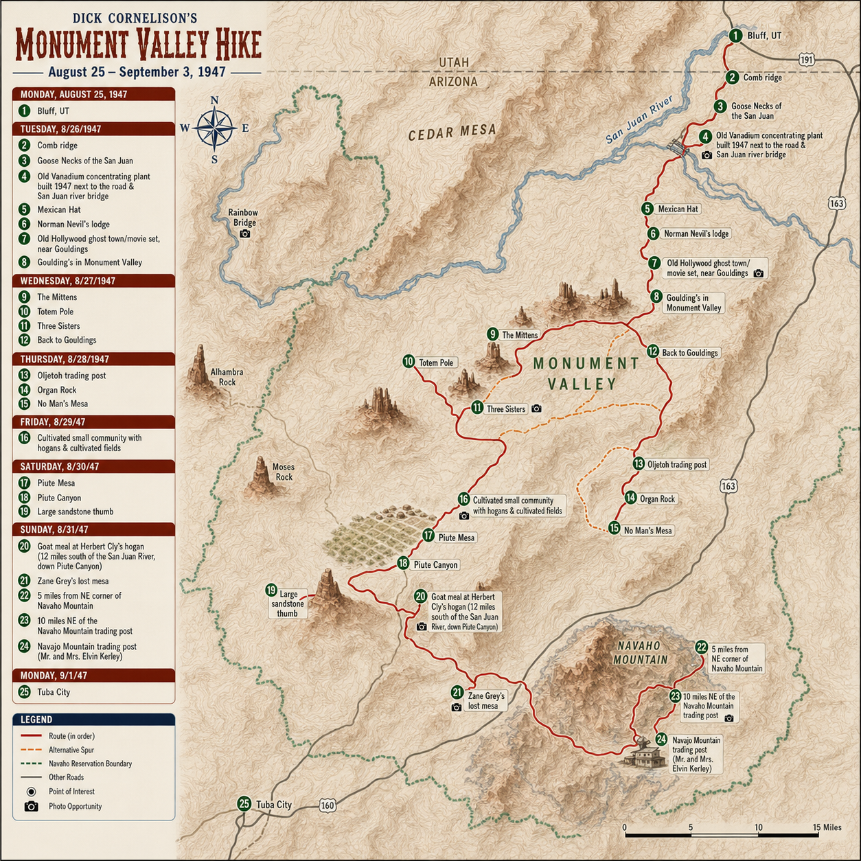
Modern map showing the Dick’s rough hiking route, noting spots from his story.
Bluff is a small village in the south-eastern corner of Utah, on the north bank of the San Juan River, which is the northern boundry of the Navajo Indian reservation. The village consists of three trading posts---although one would satisfy-the volume of trade---and several old-frame houses. There is a square school building dated 1893 which stands in the middle of the town. It dates the first serious settlement movements in that part of the south-west by the Mormon church.
The date is Monday, August 25, 1947, and I have arrived from the north via the mail stage in Bluff. After helping the driver unload his goods at the trading posts and post office I ride with him towards St. Christopher’s Mission, where he had a few large sacks to deliver. On the way we come access Brother Juniper walking the three miles into town from the mission. We have his mail and he accepts a ride with us back to the mission. St. Christopher’s is an Episcopalean mission started in 1943 by Father Liebler, formerly of New York. The mission’s personell consists besides the two already mentioned of Father Clement, a teen-aged helper, and two women. Upon arriving I find Father Liebler and the women have gene to Grand Junction, so my arrival does not overtax the rather meager accomodations at the mission.
The San Juan river valley is a beautiful, verdant strip in the midst of an arrid and rough desert country. The river valley in the Bluff vicinity is about a mile wide and the present river, the remenent of a much larger body, meanders entrenched between the bounds of rough and in some places vertical sandstone cliffs about 100 feet high. Corn, beans, and melons of all sorts are among the chief cultivated crops which thrive in the sandy river-basin, and the green contrasts beautifully with the red sandstone.
At the mission there are a few Navajos sitting in the main room, some looking at picture books and magazines, some listening to the radio. My entrance wouldn’t have been especially surprising to them if I hadn’t had with me my big and cumbersome 60-pound pack. They all smiled and finally laughed when one of the old women mumbled a few words. Father Clement, a man in his sixties, has spent most of his life on Long Island and more recently completed a mission in the Phillipines. His hospitality is unsurpassed and I feel at home without difficultly as he shows me a cot I can use that night and tells me dinner will be ready in a couple of hours.
Shortly before dinner a car drives into the mission and four people get out. They are Margaret and Vico Henrickes and Mr. and Mrs. Lockerby, the former, relatives of Doug Henrickes whom I had know in years past, owned this 1938 Oldsmobile.
The Lockerbys (and their fierce and tiny nuicance of a dog) are old friends of the Henrickes’s and are spending his vacation seeing this part of the state. Vico worked at the mission last summer and is as happy to be back as the Father and Brother Juniper are to have him.
The dinner situation now is acute and I fetch a steak from my pack to add to those already on the griddle. Finally at seven all eight of us find ourselves at the table enjoying an abundance of food. The dinner-table conversation is varied and lively except for Mr. Lockerby who sits musing over rocks and birds he had observed since his arrival. After helping Father Clement wash the dishes and waiting for the others to turn from a fluorescent-rock hunt we all attended a vespers service, which was conducted in high-church fashion. The one Indian who might have stayed for the service got tired of waiting about 10 minutes before it started, so the chapel was filled solely with white people, half of whom didn’t know the order of the service.
And so to bed under a cloudless sky. I didn’t see much of the sky because I had my cot inside an improvised teepe the mission had put up. The young boy used the teepe as his headquarters. The other guests slept in two small frame shacks nearby. Not very far away an Indian family has a hogan, and the only noise during the night is the barking of their dogs.
The arrival of the other guests has relieved me of the task of starting my trek south on the road to Mexican Hat. They are covering the same country in their car and I accept with pleasure their offer to ride south about 60 miles to Goulding’s in Monument Valley. Good intentions to get off before nine go to the wind as we are taken on a tour of the near points of interest by Brother Juniper, chief among which is a huge ruin which we can clearly see across the San Juan and several nice quartzite fields on the sandstone above the river basin. We see some good petroglyphs and see a few odd arrowhead chips and pieces of pottery. The ruin and the forementioned probably belong to the culture of Indians who inhabited this area about 100 AD.
After enjoying a sumptious watermelon feast about noon we get ourselves collected, give our thanks to Father Clement and Brother Juniper, and leave for Goulding’s via Mexican Hat.
The road gets progressively rougher beyond Bluff. The frequency of detours and detours around detours increases too. Detours are necessary because several days before the general area enjoyed heavy rains---a cloudburst in Bluff when 0.64” fell in an hour---which in the deseret means washes filled to the brim with mud-laden water and rock. About seven miles west of Bluff we start the ascent of the geologically-notable monocline, Comb ridge, whose west side is sheer and rises roughly 1500 feet. The road becomes rougher and steeper as we go, but finally we have reached the summit of the Comb and look out many miles to the west to see Cedar Mesa and to the south some of the bluffs along the San Juan. Comb ridge extends north from where we are about 75 miles and south about 100 miles. During the next two day’s travels it is the feature most often visible and is an aid in getting one’s bearings. Another 10 miles and we were at the turn-off which goes to the Goose Necks of the San Juan. The Goose Necks are about 30 minutes from the main road and offer a most spectacular and interesting sight. There we stand about 2000 feet above the winding river which has cut four symmetrical meanders in the valley floor in a distance of about a mile and a half.
At Mexican Hat, so named for a sandstone sombrearo supported on a thin pinnicle, we stop at Norman Nevil’s lodge where his mother greets us and explains that Nevils isn’t around and the lodge isn’t open for business. The San Juan is visible from the lodge, and not far from the river there are six of Nevil’s river boats on their backs. The bridge across the San Juan is several miles past the lodge. There is a small store and Indian encampment where a Vanadium concentrating plant is being constructed at the river’s edge. The bridge is a 12 ton suspension arrangement which quivers easily.
By this time we have had several glimpses of Monument Valley’s higher spires which show thru the late afternoon haze. We have in fact been looking for some time at Alhambra rock, a massive 1200 foot igneous extrusion all in black. It might be considered the beginning of the monuments. About five miles beyond the river we chance the left-branch of a fork and drive merrilly on about 15 miles before we discover we are going in the direction of so called Moses Rock. After getting back on the right road we make 15 or 20 miles before a tire gives out and stops us at an opportune view-point of the valley, its monuments standing majestically in the yellow desert haze of the early evening.
Gouldings is now about half an hour south and we drive on anxiously looking for a light on the desert. The first error is following another sucker into a Hollywood gohst town, but from there Gouldings can be seen. At Gouldings we enjoy a welcome by a coyboy who is the owner’s right-hand man and two women, Goulding’s wife and mother. After getting settled in two tidy cabins we make our way to a delicious dinner in the rustic mess-hall.
Bed feels good in such circumstances and especially when one can look forward to a tour the next day of such spectacular scenic country as this. Goulding’s right hand man, M. had the five of us on our way in his specially constructed Plymouth station wagon by eight the next morning (now Wednesday) and we headed back out to the main highway and due east towards Comb ridge, 30 miles in the distance. The deseret was fresh after a light rain that night and Morris explained that in the last week more rain had fallen than had in the sixteen months preceeding. Soap weed (of the Yucca’s) and black weed are the principal small shrubry which lend their light green to the desert, though the cedar and juniper show light green tips after some wet weather---all in all very contrasty against the pastel red and buff sandstones.
We are now looking east from a high piece of land towards the Mittens, two 1000 foot sandstone masses which from where we stand look like the back sides of two sillouted hands with fingers together. Directly to the south is Mitten Butte, a minature mesa about 1500 feet high. Getting back into the station wagon we drive carelessly down the side of a long and steep sandy hill into a wash suitable for a road. A few miles farther on we pause for a few minutes to examine an Indian sweat house, a hogan of small proportions---roughly seven feet in diameter and four feet high---used by the Navajos to cleanse themselves. They generally don’t get in the sweat houses oftener than once every few months, but when they do they undergo four heats and coolings. Stones heated in a fire are put in the small hut and after the Indian has raised a sweat sufficient to make him feel weak he comes out and rolls in the wet sand or snow if present.
After driving about five miles east we are on some sand dunes of fair proportions which form the foreground for the famous Totem Pole of Monument valley. The Totem pole is about 15 feet through at the base and rises 1006 feet. Way to the east Comb ridge has cast some shadows from its cliffs onto the desert. Leaving for a shady place to eat lunch we drive for several miles to get to an overhanging sandstone cliff.
About two miles from where we have had lunch there is a concrete wall which has been built between two sandstone runoffs, forming a resevoir for two Navajo familys. The Navajos do not live very near the water because their sheep would get mixed, so someone from the family has to carry buckets of water a mile or two or else hitch up one of their teams and little wagons. We found some little water dogs, transparent and about half an inch long, swimming in the resevoir. The Indians call them cle-sonney, phonetically. [‘water faries’ written in the margin here.]
Visiting one of the familys which lived near this water we had an opportmnity to see some Navajo weaving and get a glimpse of their abodes. An old woman, old lady Cly, was the only one of the family there. She conversed with Morris in Navajo and told him she was the mother of 12 children, four of whom had died. The corn crop was insufficient this year to take the family through the winter and the old lady wasn’t sure what they were going to do for food. She was dressed in a heavy green velvety skirt and a faded red velvety blouse. She had a few silver ornaments sewed on the blouse and wore keds on her feet.
A few hundred yards from the hogan the family sheep and goats are grazing on the sparce deseret weeds and grass. Near by stands a brightly painted wagon about five feet wide and 18 feet long with very large wheels. Most familys have these wagons to make long trips in and to haul their water.
From the hogan we drive back towards the trading post (Goulding’s) over a different route. The first point of importance is the nicely preserved set of three round cliff dwellings under a large overhang. The cliff dwellings are in a canyon about half a mile wide and the echos are as good as any I’ve heard. One loud yell will last for 12 seconds. Not far from the dwellings are some large and well-preserved petroglyphs---snakes, deer with many points, and mountains. On a few miles farther west are some cliff dwellings of an entirely different nature---rectangular like the cliff dwellings of Mesa Verde. This type of cliff dwelling is the most common and before the end of the trip I had seen several more.
A few drops on the windshield indicate the nearness of a rainstorm. In the desert the rain starts suddenly, falls hard and heavy, and stops abruptly. Besides the localized nature of the rains they are unusual both because of their heavy complement of thunder and lightning and because the thinly distributed vegetation makes the run-off immediate and often violent. The storm commences with rain which in five minutes has become pebble-sized hailstones, but there is enough moisture inside of 10 minutes to make water cascade off the sandstone monuments. The small washes are filled a foot deep and the larger ones are carrying besides mud and water some fair sized boulders. The shower has soon passed though and leaves the desert fragrant and fresh. After waiting for a wash about 30 feet wide to go down some we proceed off across the deseret biding good-bye to the Three Sisters, a trio of monuments resembling hooded sisters.
Another half hour over a sandy and rough road and we are back at Gouldings where eight guests have arrived. After another delicious dinner I read some geological buletins and study a few rough maps of the area which have for a number of years been out of print. Tomorrow marks the first day on foot and probably the last day near any sort of road before I reach the other end of my prospective journey. After considerable speculating and map reading I had decided several days before that if possible I was going to leave Gouldings and attempt a trip due west to Navajo mountain, 40 miles as the crow flies. So that night I readied my pack, sketched a few maps, and made some sketchey notes on the points of geological interest that I might see on the way
I was fortunate to have a fairly heavy rain-fall that night, in fact the rain-fall probably marked the second lucky break which went to make my trip not unsuccessful (the first being the ride with the Henrickees). August is the wetest month on the reservation and means besides batter grazing and crops that wayfarers can more successfully walk across the desert: upon getting wet down the sand gets somewhat of a crust which makes walking much easier; also the water problem is solved since slickrock water-pools can be located with a little searching.
Oljetoh trading post is twelve miles from Gouldings and in the direction of Navajo mountain. Now five o’clock Thursday morning, I swing my overloaded pack on my back and head up a wash which goes in the general direction of Oljetoh. After tramping for an hour I decide breakfast would taste good.
No sooner is the fire underway than some tinkling goat bells and barking Indian dogs forewarn that a herd of sheep and goats is coming in my general direction, thus making it advisable to kick out the fire and get underway again---this being the first encounter with Indian dogs I didn’t wish to risk getting them unhappy.
Walking on further in the wash it widens and runs into a valley a mile wide and running roughly north and south, in which there is a road and windmill. This must be the road to Oljetoh, but to the south a storm is quickly running up towards me and I have to walk quite a distance to a rock which appears to offer good shelter from the impending rain. Within five minutes quite a torrent is pouring into the valley and the prarie starts running water all over. Eating a breakfast of cookies while sitting waiting for the storm to pass, I reason that I have made myself some extra walking by not taking a side wash off the big one I have just come down, so it isn’t likely that I’ll get to Oljetoh until late morning.
The road to Oljetoh runs right in the middle of this mile-wide valley and on the way I pass several Indian familys, who climb out of their hogans and gaze at me trudging along with the tremendous pack bending me over 30 degrees. The most refreshing sound for many a day reaches my ears as several Navajo horsemen riding up from farther down the valley sing some of their native songs, which echo and reecho in the valley’s walls. Most of the horsemen seem bound for Oljetoh, and as they pass me on the road they recognize me and seem reasonably friendly.
Finally Oljetoh shows its tin roof above some brilliant green tree tops and I take off my pack about 11 o’clock. Inside the trading post four Indians are standing idly about and the store-keeper, a fellow in his late twenties, is stocking his shelves. Upon asking the condition of the trails to Navajo mountain the Indians and storekeeper commence talking among themselves, after some minutes reaching the conclusion that none of them know much about it. But there is a man a few hundred feet up the trail going to Navajo mountain---walking---and this seems to be the third lucky break of the trip.
Not far from the post there is small wash still swollen from the shower earlier in the morning. The Navajo man has by the time I reach the water gotten to the other side, replaced his shoes and walked on over the crest of a hill. So I hurredly take off my shoes and stockings and run as best I can until I catch up with him and get him stopped. “You are going to Navajo Mountain?” He nods his head. “I would like to give you three dollars if I can walk to Navajo mountain with you.” That seems to register no unpleasantness on his stolid face, so after getting, my footwear back on we start off and loose Oljetoh behind some sandy hills after half an hour.
My Navajo guide is not especially athletic looking, though firm, and is about five feet 10 inches and about 150 pounds. He looks about 40 years old. His garb consists of a large black hat under which a large bob of hair is tied with white stains, a denim work shirt, a plain belt on some plain greyish pants, and new ankle-high work shoes, without socks. Over his shoulders he has a rolled blanket full of goods he has bought at the post.
Catching up with him I notice his fast yet unbroken pace. The slow pace suited me well because my pack was pulling me down and the desert was getting hot in the noon sun, but apparently the first hour was a warming-up period. After a bit he is taking strides almost as long as mine and probably knocking off close to four miles an hour, which is the upper limit of comfortable walking in rough terrain. In a little over an hour my pack is making my shoulders ache to such an extent that I began thinking of a graceful way of making a 10 minute rest stop. The camera seems the best out and I becon to him to stop, which doesn’t make an impression, so I finally sit down on a big sage brush and he turns around and stands waiting to see what is going to happen. A few minutes back we had rounded a small mesa and he pointed to Navajo mountain off in the distance and mumbled its name. Where we were now stopped the mountain loomed up from behind an immense mesa, so I had him stand in the foreground as I snapped a picture of the mountain. Seeing that the stop was to last a few minutes he put down his pack and stood around, but his predominant feeling seemed to be keeping steadily on the go. I lightened my pack by four oranges, two of which he apprecited visably. A pint of water in the canteen seemed unnecessary in light of the recent rain, and I knew the Indian wouldn’t have trouble finding water, so I disposed of it. My error was drinking it myself---a cardnal rule of desert is not drinking water in the middle of the day.
Now an-hour later, I-am beginning to feel the effects of a lot of hard walking behind my Navajo, besides the miles I put in earlier in the day. The time is about one-thirty and we have crossed a good stretch of desert with a mesa in front of us, quite obviously necessary to go up. The day has cooled a little thanks to some rain clouds moving in from the south. During the past hour I have given the Indian about five pounds 0f my canned goods on two occasions---the trip isn’t going to take as long as I had expected and I need to lighten my pack.
But I am fagged out and I see no other out than to tell my Navajo to go on his way and that I will come on later after resting. Explaining with the best sign language that I knew that he should not wait for me and that I will come later,
I give him his three dollars and bid him good-bye. Before he gets on his way though he shows me that I have to cross this mesa, go down a canyon, cross another mesa, go down its canyon, and then wind south and east over a plain towards the mountain.
The shade of a big black-weed feels so good that I decide to get out my sleeping bag and rest for some time before moving on. The rain clouds have inside half an hour though come so close that it seems advisable to get prepared for a heavy shower, so I get all perisables deep inside my pack, place it back side up on a big weed off the desert floor and sit watching the lightning and rain sweep over a distant mesa and down in the valley towards me.
The rain is falling so hard that every two minutes I have a hatfull of water to empty into my canteen, and the frying pan fills up every five minutes. The washes, and especially a big one a hundred feet to the east, are several inches deep with red water and sediment, all going eventually into the San Juan (about 15 miles north), the Colorado, and the Pacific.
After the rain moves past me I sit patiently by several little pools of water scooping small cupfulls for my canteen, having decided that I will camp this evening with an abundance of water.
About three thirty I have finally gotten my pack together and walk on up a gently rising plane which dips from the mesa. The rain has left two nice rainbows in the part of Monument valley which is still visable and I have the camera hung from my neck ready for action. A sandstone mass about two miles away looks very much as though it meets the description of Organ Rock, and when a rainbow opportunely pops up behind it I attempt a picture. About half a mile from the mesa an Indian on horseback rides over a crest and pauses long enough to find out where I’m headed. He speaks broken English and doesn’t get many of my questions. The trail is not hard to follow except where it runs up washes where water has run today. Not very often can I distinguish my Navajos footprints, but there are no forks in the trail and leaves no doubt that I am right. The ascent of the mesa takes about an hour of my leisurely walking, the trail zig-zagging in the sandstone ledges and rising roughly 1200 feet. The last few hundred feet I look for the last time into Monument valley and in the other direction look into a scarlet sky as old sol sinks behind Navajo mountain, now about 30 miles off.
The top of the mesa is an expansive prarie of sage and juniper trees which has on its northern reaches another mesa rising out of it---a multicolored mass with an area of about 60 square miles. The latter is about 1500 feet above the mesa I am standing on and its southernmost part is about half a mile north of me. The higher mesa protrudes out of its base very abruptly and at its foot lies some very rough sedementary material colored predominately green from copper ores. From the maps the higher mesa is No Man’s Mesa, so named for the difficulty in getting on top of it. One geological report claims that a possible though tough ascent can be made on the north-western comer of No Mans’s mesa, but the trail I am on will not approach that part of the mesa.
More rain showed itself in clouds far to the south, so I knew the highest parts of the mesa would be unwise because of the severe lightning which would come later in the evening. Walking till dusk I got to a low dip in the central part of the mesa. Sitting huddled up for two hours two storms finally passed and left the near-full moon shining through some light haze. I was now looking at a rainbow extending over No Man’s mesa and caused by the moon was not nearly as bright as a sun rainbow but was otherwise a fair repleca.
The sun rose Friday in a cloudy sky and I slept late in the cool morning, finally getting breakfast cooked end the pack together at nine. I had stopped about half way across the mesa and walked for an hour before I came to the other side’s zig-zagging trail. This side of the mesa held a deeper canyon.
The canyon is about 250O feet deep and no very abrupt from where I am standing---the canyon floor is quite wide and slopes up gradually to the cliffs of the mesa. On the other side another mesa rises quickly out of large piles of talus and sedimentary waste. It is probably four miles across the canyon because I cannot make out the trail on the cliffs on the other side.
About one o’clock I am out of the canyon bottom and up the other side about 1000 feet---on the talus and looking up at the towering sandstone cliffs of the mesa which I am about to ascend. After eating a can of tomatos and some cookies I go a bit farther and crawl under a big overhanging rock to rest from the hot early-afternoon sun. A few cries from farther on up the trail tell that an Indian will be along in a little while. Some minutes later I am aroused by an old Indian couple on horseback followed by three burrows. He is friendly, extending his hand as soon as I walk up to him. After explaining to each other where we are going (in broken language and signs) he speaks to his wife who brings out of a little bag three small peaches. I accent and eat one, which tastes sweet and is very good. He explains that the peaches came from the mesa he has just come down from and which I am about to go up.
About four o’clock I had attained the top of the mesa and gazed out towards Navajo mountain, then apparently quite close---a matter of a days walk. A ways farther the juniper’s broke and a cultivated valley showes that several Indian familys live on the mesa. The cultivated part of the valley is about two miles long and half a mile wide and close inspection shows that there is considerable nice grazing land on either side. Walking farther down into the valley I see that the cultivated land is enclosed by a three-strand barbed wire fence. Way on the ether side of the fields a man is walking along with a little child. They and a dog are tending a band of goats and sheep. Scattered through the valley are five hogans plainly visable. Smoke is curling out of one of them. The fields consist of corn growing about eight to 10 feet apart in fairly straight rows and along the edges of the fields are some squash and melons and an occasional fruit tree. The man and child have seen me coming and have gone behind a crest and tried to lose me, but upon walking over towards them the dog comes out to meet me and they peer over the crest. By this time I have decided that the Indian dogs aren’t as mean as the average city hound, so I pay little attention to the animal as I walk up and shake hands with the old man. He knows no English except ‘Navajo mountain’ and ‘water’, which are about the only important things of interest to me now anyway. He indicates the trail is up a wash on the other side of the valley and I head for it expecting to pick up as clear a trail as I had left when I got into the valley.
But no trail shows itself and when I see a group of three active hogans I drop my pack and advance to find out what I can about the trail to Navajo mountain. The only people immediately available are some young women who know absolutely no English and probably haven’t seen a dozen white-men in their lives. After some futile sign language a man crawls out of one of the hogans and upon the first hello shows that he knows quite a bit of English.
We carry on a fruitful conversation for about 10 minutes, when a spanking new wagon and lively team is driven up by one of his friends. He seems to be going somewhere, so I tell him I have food in my pack I could like to give him, to keep him from leaving right away. He takes me to large hole in the rock where quite a little water is stored and I take enough water for the night. Before leaving him I have him sketch a trail which will get me to Navajo mountain in about five hours he says. This trail is a foot trail and goes more direct than the horse trail, but it is harder to find he says. Nevertheless, the day before his father used it (his father being the old man with the little boy out tending the sheep) and I would be able to follow his foot-prints.
So I head up the wash a half mile and make camp for the night. This night no rain will bother because the sky is perfectly clear. The next morning now at eight and I am on my way to the head of wash which I had started up last night. It takes me to a higher part of the mesa where I can look out over the country I am going to have to cover during the day to get to Navajo mountain. It is a country of mesas split many ways bv washes, some very deep. The plain in front of Navajo mountain slopes toward a sheer cliff whose bottom I cannot see. The plain looks quite smooth, but being about 10 miles from it there no doubt are many washes and irregularities.
Four hours hiking and I am halted for lunch at the edge of the major canyon which runs between me and Navajo mountain. The place where I am is at the edge of the first of two dry waterfalls which must each go down 200 feet. It looks easy to get down the side of each of these into the canyon they are in and thense into the major wash.
Maps show that I have been on and am now on Piute mesa and that the major canyon which cuts between Piute mesa and Navajo mountain is Piute canyon. Further inspection shows that below the two dry waterfalls there is a vertical drop of at least 1000 feet, so I go over to the rim of the canyon to get a good look down in it and discover that the sides are very sheer and that the canyon floor is about 3000 feet below the mesa. Going down into it without a trail would be impossible and getting out equally impossible. Scanning the other side I see no possible trials going up the sheer cliffs, but there are two small canyons they stem off into the Navajo mountain plain. I cannot see into either of these and there may be a trail in either. But getting down is the first problem and no possible trails show themselves. A glance to the north shows a huge bad-land of blue, red, and green-hued rock lying in Piute canyon’s lower extremities near the San Juan river. Having no idea whether I am too far north or south on the canyon rim, I presume the trail couldn’t run through the bad-land and hence started south along the rim of the canyon. Fortune turns my way now as I stoop over to pick up an object which looks much like an arrow head. It turns put to be a nice spear head three inches long and made of brown flint.
Not much later the realization comes that I have been off the trail all day, can now not see the trail, and do not know whether I am too far north or south to get the trail. Under such circumstances one does best to locate himself and find some definite means of getting back on the track. The only alternative is to retrace my steps and get back into the valley in the middle of Piute mesa.
The tramp was long and hot and I made my way too far south in getting back to where I had started from in the morning, but about dusk I stumbled into the valley along a wagon trail which I had picked up two hours before when I climbed a large sandstone thumb which rose quite a bit out of the desert. I was absolutely worn out and didn’t have the energy to turn a hand and get anything to eat. After spending quite a little time looking for some water I decided that it was futile. The Indians who the day before had given me water from the hole in the rock had moved out of their camp and the hole in the rock was bone dry.
Arising the next morning at sunrise I walked down the valley towards a group of hogans where there seemed to be quite a little activity. On the way I came upon a Navajo, walking up the valley. I said, “Where is the man who talks English and who lived up the valley a ways yesterday?” “They must have moved up the valley.” Or in other words this man spoke English too and served the purpose equally well.
“I’m trying to get to Navajo mountain and lost the trail yesterday. Can you go over there with me or show me the trail?” “Yes. Can you ride horse?” “Yes.” “Go up to the end of the corn fields and you will see some hogans. Meet me there at noon and we will leave for Navajo mountain.” He said in addition that I will find water just up the wash from the hogans. After half an hour I arrive at the hogans and walk on past to the water, where I sipon some from the large barrows which are standing in the wash. The old lady in the hogans spotting me taking her water and not understanding who I am begins to start towards me, so I close my canteen and walk up the hill towards her. She goes back when she sees me coming.
Up a little knoll two hogans and a lean-to made of juniper boughs comprise this familys summer quarters. There is an old lady sitting under the lean-to and a girl about 18, another about 22, and five children all under five. Sitting down I make it plain as best I can with sign language that I met their man up the valley and that he said that I could take some water. Then I explain that he and I are going to Navajo mountain at noon today.
The girls have shyed away quite a bit and have stopped their weaving. The old lady doesn’t seem much disturbed by my presence. In a few minutes the old lady begins to talk considerably to the girls, who later leave the shade and head for the flock to get a young goat, which is apparently going to be milked. But they slaughter it, skin it, and within five minutes have it quartered and ready to cook. The old lady meanwhile has built up the fire where she has been cooking corn since I arrived and has some water boiling in a very large kettle. She almost immediately has the quarters cut up and in the boiling water and it is becoming apparent that a feast is underway.
About half an hour later I am sitting with a cloth sack spread in front of me on which is a pan with five ears of corn, a large bowl of meat, a pot of coffee, a sack of sugar, and a piece of bread eight inches in diameter and half an inch thick. Hunger disperses any inhibitions I have about the cleanlyness and I dig into the first food for a day.
I have been fed first and the children are now taken care of. The corn is about the size of the golden bantam commonly on the market, but the kernals are white with a few black ones intersperced. It is sweet and juicy. The old-woman steam cooked it with the husk on. The bread is a mixture of flour, baking powder, and water poured doughy on a wire griddle right in the coals of a fire. The goat is the least appetizing of the menu. Its smell predominates over all and the tenuous stuff has a very flat taste even after lots of salt. The Indians miss not a morsel of the meat, which is very scarce among the many bones, and when through with the piece they have worked on they toss it over their shoulder to the dogs. The coffee is made by dumping grounds in water, boiling, and settling with cold water. I didn’t get in on the desert course, which was a yellowish paste kept in a big pan so when ever anyone needed some they could stick their hand in and lick it off.
After about an hour and a half I finished all I could hold and felt very well satisfied and appreciative. The Indian I had seen earlier in the day now appeared and sat down to eat and told me to have some more with him. I downed two more ears of corn while he ate a tremendous meal. This Navajo happened to be the man I had seen Thursday on horseback on the trail. He remembered me before I recalled seeing him.
Herbert Cly is his name and his father’s mother is the old lady Cly of Monument valley (Cly means left hand). Cly has gone to Tuba City to school for five years after finishing three years of elementary school near Navajo mountain. The fellow I had seen on the mesa two days before spoke much better English and had gone to school the same length of time. Neither had been in the service though both had to register, though Cly laughed when he told about the month he had to spend in jail in Salt Lake because he didn’t register. He saw his first railroad on that trip and mentioned that none of the others in his family had seen a railroad. For that matter, I don’t imagine that some of the small children in his family had seen a white-man before.
Cly’s wife was the girl 22. He had three children. I never was able to understand the relation of the old woman or the other younger girl. The old woman apparently owned one of the babies, but there was one still unaccounted for.
Now finished with dinner, Cly and I went over to the two Navajo ponies he had brought in. He gave me his best pony and best saddle and used his wife’s saddle with a blanket for himself. My saddle was a regular western saddle and a good one. His wife’s saddle was very deep and had a big collar on either end, which someone told me was to balance the papose on.
I decided to have a look through the other huts before we left. The old lady was sitting inside the main Hogan. It was a log hut about 15 feet in diameter and seven feet high in the middle with a hole in the top. It was plastered with red mud on the outside and was cool when we went in it about noon. There was a small board shelf all the way around and about four feet off the ground. On it were all sorts of merchandize and trinkets. The Navajos like Pendleton blankets better than their own. This family used as many Pendleton’s as blankets they had made themselves. Cly had a wagon under a tree which he said he paid $250 for. He asked me the price of that sort of a wagon in Salt Lake along with some other things he had. In another hogan not as nicely constructed as the first he had all his saddles and leather goods along with a few sacks of flour. Inside of two minutes I had seen almost all the man’s capital wealth aside from his horses. His jewelry amounted to quite a bit. One turquoise and silver braclet amounted to $l00 he said, and the children and women had an easy $500 in turquoise and silver.
The ponies were about average-sized riding horses. His best pony was seven years and he had been riding her for five years, He owned 10 ponies in all and after riding one for a day or two turned it out on the mesa to graze for several days or a week. My experience with horses leaves me in no position to judge the horses, but to me they were the best I had ever riden and couldn’t have been better. Their fine spirit combined with sure footing and no scarryness made the trip very easy and quick.
Giving the old lady all the change I have in my purse I mount and ride off in the direction of the place where I camped the night before and left my pack in the morning when I left on the search for water. Dissembling the pack and putting it on the horses takes quite some time and it is one thirty before we get on our way to Navajo mountain.
The trail leads up the valley about a mile before turning west up an insignificant wash. Had I gotten off to a good start on this trail the day before I would have saved myself considerable trouble---the short cut cost me over one day of lost time. The horses run, walk, and trot intermittently and without provocation. For some time we skirt the canyon and then drop into a wash where the sandstone layer which all through that country forms the impassible ledges has broken into talus considerably. Nevertheless the trail is blasted out quite a bit of the way.
We are decending into the bad lands which the day before I reasoned wouldn’t be the likely place for the trail. Cly says that the San Juan is about 12 miles north down Piute canyon from where we are, but it is obscured by a huge anticlynal mountain which marks the general ending of the bad lands. A large land feature just north of Navajo mountain is visable from most points on Piute mesa. It looks to be a gigantic grey mesa, which may answer the description of Zane Grey’s lost mesa. Decending still farther into the canyon, the walls obscure even Navajo mountain. A small trickle of water in the canyon bottom is now discernable along with a peach orchard about 500 feet square. Still farther on a big hogan cones into view. It is behind the peach orchard and up against the west side of the canyon. A smaller canyon draining the Navajo mountain plateau joins Piute canyon just where the hogan and orchard are located. This is one of the canyons I couldn’t see up the day before, and on its side zig-zaged the trail---the sheerest wall I had seen on the journey.
The Indians in the hogan are good friends of Cly and we have placed before us a large bowl of peaches, coffee, and a pan of bread with Karo syrup on it. The family numbers about eight. The eldest man, about 50, and a young man speak English. They explain a bit about getting from Navajo mountain trading post to the Rainbow Natural Bridge and Wilson’s.
Another family is stopped at the hogan when we arrive. A woman about 40 with a papose and a little boy are driving three burrows toward Navajo mountain. About 10 minutes after they depart we begin the climb. A little way up the side canyon we pause to let the horses drink from a spring. Going up the wall of the canyon takes about half an hour, but it seems like 10 minutes. About 100 feet from the top we come across the woman carrying her papose, the boy riding one of the burrows, and the other two burrows following. She shows no signs of being tired even though she has walked up about 3000 feet at about three and a half miles an hour---just slightly slower than the horses. Cly tells me that her husband died last year.
Once on the level prarie the horses run along for some distance apparently in the spirit of happiness. The mountain now lies about five miles ahead, but we are at its north-eastern corner and must go about 10 miles south and west to get to the Navajo mountain trading post. The prarie which from 10 miles away appeared quite even assumes a series of rises and washes running perpendicular to our line of travel. We are now three hours out and Cly says we should be there in another hour. I estimate the distance at 20 miles, or five miles an hour, a very good pace for such terrain.
When Cly unpacked and dissembled my pack he noticed my Kodac, so he asked me to take his picture as we were riding along. Actually he was as interested in having his horses’ picture as his own. I took two photos, changed the film and took two more which seemed to suit him well enough. When getting off the horses in the desert one merely drops the reigns. Even towards a stranger they act perfectly.
The shade of the mountain finally overtaking us about six o’clock (Cly underestimated the time), we rode on for 20 minutes before a truck finally leared up on a very unkept road we had turned into a few minutes before. A quite British voice asked me if I was going to the post and replied when I told him I was [but] that the trader wasn’t there. After dismounting and taking off my hat the man realized that I was a white man, so he shut off his motor to take a minute to listen to my troubles.
I explained that the chief object was getting out where I could catch a bus to Salt Lake, for by this time the vacation time was setting short and I wasn’t going to be able to get to Rainbow Bridge. He said that Wilson’s, where pack trips to the Bridge originate, wasn’t a very likely place to get a ride out and that the Indian day school up towards the trading post might have a truck going to Tuba City in the next few days.
I beconed to Cly and we got the stuff off the horses in preparation for departing. The post was only five minutes up the road and Cly wasn’t going to bother to go up because he wanted to get back before too late that night. When I first saw him in the morning I had agreed to pay him $10 for the trip, an easy overpayment of 100%, and when I gave him the money he seemed mildly pleased, shook my hand, and got busy shortening the stirrups of the saddle I was using so he could ride that horse back.
My host was a Baptist missionary, Harold E. Baer, who had been in the Navajo country for a month. His accent was an effected Virginia and New York tongue. His wife was in her late twenties and hailed from Binghamton, N.Y. They had a son and daughter under seven.
The next day, Monday, the trader came in. Mr. and Mrs. Elvin Kerley were very hospitible people and invited me to dinner that night. They had a baby a few months old and were also a young couple in their twenties. Kerley was raised in the Navajo country and learned the language as he grew up, the only way to learn it well.
On Tuesday a truck left for Tuba City. The Indians in that section of the country who were attending the higher grades had to ride out to Tuba and go to school either there or whichever of the other Indian schools they choose. The truck was loaded all the way. One young boy had tears in his eyes as he left his family. It would be a year before he returned probably.
About one o’clock we arrived in Tuba City (via Inscription House and Tonalea) and I got off to wait by the roadside for a ride to the main highway.
Going up to the Indian office in Tuba City I phoned to see when the buses were runing to Salt Lake. One went early in the morning and one at eight in the morning. Since there was rain in the offing I decided that it would be well to wait till later in the afternoon and then try to get out to the main highway. At five I got a ride eight miles out and walked the remaining five miles over some small hills.
Seven hours later I was aboard a Sante Fe bus bound for Salt Lake and a most enjoyable and inspiring trip had been completed. As I left the bus the driver was surprised to see that it was not a Navajo that had boarded the bus at 2:00 AM and had to collect a fare. A phone call to my home produced the money needed, as I was completely out of funds, the last money having been given to the Navajo squaws as a reward for dinner a few nights before.
Notes
-
For more interesting reading about the Cly family from Monument Valley:
-
Read [https://chicagoreader.com/news/mystery-in-the-desert/](Mystery In The Desert) by Mike Sula, Chicago Reader, or
-
View the movie adaptation, at www.navajoboy.com & available on PrimeVideo.
-
Correcting the spellings and grammar was purposely avoided—the text should read as Dick originally wrote it.
-
The three photos of Dick in this document are not associated with this trip. We’re confident that Dick did not travel with the mule, Balu, on this trip. The pictures mentioned in the article have yet to be located.
-
John clearly remembers being told as a youth by Dick that he was close to dying of thirst and was saved from probable death by a Navajo who helped him find water and helped him on his way. (This likely being Cly.) The pool he found and drank out of clearly had sheep dung floating in it, but his need was greater that his concern for his safety.
-
Margie has since added that she remembers that Dick was starving also and that they fed Dick, despite his not having any money to repay their sacrificing a lamb for him.
Itinerary
Monday, August 25, 1947
- Bluff, UT
Tuesday 8/26/1947
- Comb ridge
- Goose Necks of the San Juan
- Old Vanadium concentrating plant built 1947 next to the road & San Juan river bridge
- Mexican Hat
- Norman Nevil’s lodge
- Old Hollywood ghost town/movie set, near Gouldings
- Goulding’s in Monument Valley
Wednesday 8/27/1947
- the Mittens
- Totem Pole
- Three Sisters
- Back to Gouldings
Thursday, 8/28/1947
- Oljetoh trading post
- Organ Rock
- No Man’s Mesa
Friday, 8/29/47
- Cultivated small community with hogans & cultivated fields Saturday, 8/30/47
- Piute Mesa
- Piute Canyon
- large sandstone thumb
Sunday, 8/31/47
- Goat meal at Herbert Cly’s hogan (12 miles south of the San Juan River, down Piute Canyon)
- Zane Grey’s lost mesa
- 5 miles from NE corner of Navaho mountain
- 10 miles NE of the Navajo mountain trading post
- Navajo mountain trading post ( Mr. and Mrs. Elvin Kerley)
Monday, 9/1/47
- Tuba City & Home via Sante Fe Bus